Spontaneous Potential (SP)
|
Locating Fractures and Faults |
|
Relatively small natural currents, in the order of several tens of millivolts, have been measured in the ground in numerous places where certain anomalous geologic conditions occur. One known mechanism for the local generation of these currents lies in the difference of potential between oxidizing electrolytes above the water table to reducing zones below it in some ore bodies. Natural currents flow between these two zones, They can be relative strong in ore bodies containing sulfide minerals. The mapping of potential difference, or gradient, can delimit these ores.
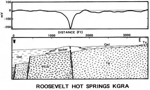
A streaming potential is the result of the movement of fluids containing ions. Such fluids may be ascending or descending along fault and fracture zones and measurements of the sp field can indicate the presence of these structures.
Another mechanism is a global phenomenon wherein there are current patterns in the near surface geology that have their driving cause in the movement of ions in the atmosphere. These movements are, in turn, controlled by the earth's magnetic field which directs the path of these charged moving particles to the north or south poles, according to their positive or negative charge. The field is essentially uniform in the atmosphere, but it penetrates a few hundred feet into the ground where inhomogeneous geologic conditions can distort the field. Mapping these distortions is an indication of anomalous geology.